Keweenaw Time Traveler
  • Home
  • ABOUT THE PROJECT
    • About the Data >
      • About the Maps
      • About the Datasets
      • About Sharing Your Stories
    • Behind the Scenes
    • Our Partners
    • Our Funders
    • Meet the Team
    • Citizen Historian Apps
    • Time Traveling Experiences
    • Publications
  • Upcoming Events
  • Project News
  • Help

Congratulations to the Class of 2021

4/30/2021

0 Comments


Since its inception, the Keweenaw Time Traveler has been blessed with many talented, creative, and engaging teammates. Today, we celebrate the graduation of four peers and teammates!

Brooke Batterson received her Bachelor of Arts in History. Brooke's research focused on French-Canadian social mobility in the Copper Country. 

Tim Stone received his Bachelor of Science in Sustainability Science and Society. Tim received the Department of Social Sciences Outstanding Senior Award, researching the built and social environments of children's experiences in 20th century America's industrial cities. 

Both Brooke and Tim will be joining the Department of Social Sciences Industrial Heritage and Archaeology Program in Fall of 2021.

Mason Sayles received a Bachelor of Science in Software Engineering. Mason contributed greatly to expanded search options within the Time Traveler. One of the upgrades included improved through social media.

Sabrina "Cas" Tuson received a Bachelor of Science in Applied Physics. Cas worked behind the scenes as a Transcriber with our project, Mapping Miners at Home and Work. This project involves digitizing and mapping 40,000 employee cards from the Calumet & Hecla Mining Company!
​
Zach Dill received a Master of Business Administration. Zach also worked behind the scenes on, Mapping Miners at Home and Work and worked with the pilot version of this project in summer 2018. The pilot's success helped secure the grant funding making our current project possible. Check out his video here!
Picture
Picture
Mason Sayles (L) and Cas Tuson (R)
0 Comments

Historic Coastlines: Using Geospatial Technologies for Coastal Resiliency

4/8/2021

0 Comments

 
​
For the past four years, the Geospatial Research Facility (GRF) has partnered with Michigan's Department of Environment, Great Lakes, and Energy (EGLE) to research geomorphological processes at work by harnessing the power of geographic information science (GISc) and historical imagery. After a fifteen-year period of near historic lows, all of the Great Lakes have exceeded their average monthly levels since 2014. While seasonal variations are common, both persistent lows and highs present their own unique dangers for coastlines, for homes, and for businesses that depend on the Great Lakes. Hydropower and boat-related activity particularly suffer beneath reduced water levels while sudden increases in water levels present threats to our shores and coastlines. By early 2020, the Michigan Municipal League estimated high water damages to public lands and infrastructure had reached $63.7 million. 

The GRF uses geospatial technology and scenario-based land-use planning methods for the purpose of protecting our coastal resources and strengthening our coastal communities' resilience in the face of coastal hazards. The GRF's team of GIS analysts began with an archive of historic aerial imagery spanning eighty years. The team meticulously georeferenced the images against contemporary shorelines, developing a photomosaic of our past shorelines at well-documented intervals and digitized the past shorelines and bluff lines. The GRF can use these digitized shorelines to visualize and analyze change over time, modeling the rate of coastal change and  applying a Coastal Vulnerability Index (CVI) for identifying areas more vulnerable to erosion. 

Understanding our coastal change over time provides critical data as EGLE responds to the growing erosion problems faced by our coastal communities.
Picture
The GRF's viewer for Lakes Huron and Michigan
Click Here for the Lake Michigan and Lake Huron Historical Shoreline Viewer
Picture
The GRF's Lake Superior Viewer
Click Here for the Lake Superior Historical Shoreline Viewer
Financial assistance for this project was provided, in part, by the Michigan Coastal Zone Management Program, Michigan Department of Environment, Great Lakes, and Energy, and is supported through a grant under the National Coastal Zone Management Act of 1972, as amended, administered by the Office for Coastal Management, National Oceanic and Atmospheric Administration.
Picture
0 Comments

Study: Schools as Vectors of Infectious Disease

4/4/2021

0 Comments

 
During our current pandemic, we all have had a lot of concerns about how COVID-19 is transmitted from person to person. One area we do not know a lot about is how the coronavirus disease is transmitted between school children in their day-to-day lives. To begin to answer these questions, researchers from Michigan Tech's Historical Environments Spatial Analytics Lab and the Keweenaw Time Traveler project have recently published a paper entitled, Schools as Vectors of Infectious Disease Transmission during the 1918 Influenza Pandemic.
Picture
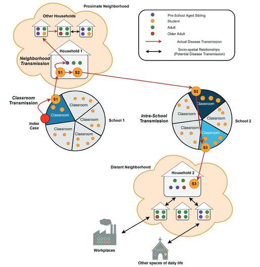
Conceptual contact network with schools as primary vectors for disease transmission
This  study integrated  three  types  of  historical  micro-data  with  a  spatially–temporally  linked  Historical Geographic Information Systems (HGIS)  known  as  the  Copper  Country  Historical  Spatial  Data  Infrastructure  (CC-HSDI).  The  CC-HSDI  (also  known  as  the  Keweenaw  Time Traveler) is built on temporally accurate Sanborn Fire Insurance  Plans  linking  built,  social,  and  environmental  variables  from  1880  to  1950. The paper utilizes a number of big historical, spatial datasets embedded with the Keweenaw Time Traveler to map and presents a novel model of ways that infectious disease evidently traveled through three schools in Calumet and Laurium during the 1918 influenza pandemic.  The study highlights the utility of using historical microdata from the Integrated Public Use Microdata Series (IPUMS), which is data at the finest, non-aggregated level of precision. Together with HGIS to overcome challenges other studies have had in tracing historical pandemics.
Picture
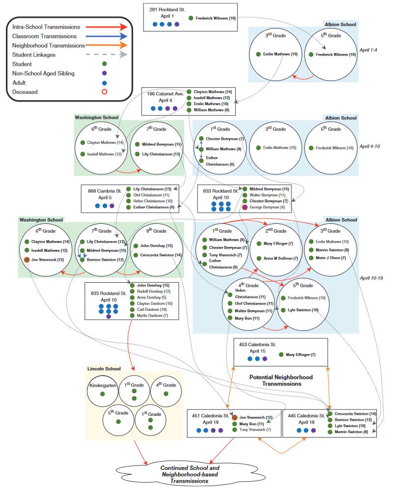
Microdata-generated spatio-temporal patterns of disease transmission in schools during the 1918 pandemic
The results are a quasi-contact tracing method that highlights the key role that schools play as vectors of infectious disease transmission. By utilizing historical big data, like that found in the Keweenaw Time Traveler, we can inform present day models that aim to combat our most infectious diseases, such as COVID-19 and others.
0 Comments

HESAL Students Present Research

4/1/2021

0 Comments

 
Pavlis Honors College hosted this year's Undergraduate Research Symposium virtually, and two of our Undergraduate Research Associates presented their scholarship to their peers.

First, Brooke Batterson presented on French-Canadian social mobility. Many of you will be familiar with Brooke's work from our earlier posts on French-Canadians in the Copper Country and her storymap on Joseph GrĂ©goire. 


Second, Tim Stone presented his continuing research into the built and social environments of children's experiences in 20th century America's industrial cities. Tim previously won the Department of Social Sciences Scholar Award for his early research on these spaces, and is also a co-author on a recently published paper that highlights on schools were vectors for disease transmission during the 1917 influenza pandemic. 

We are quite proud of our Undergraduate Research Associates and their scholarly excellence. Way to go Brooke and Tim!

0 Comments

    Archives

    February 2023
    January 2023
    December 2022
    November 2022
    October 2022
    September 2022
    August 2022
    July 2022
    June 2022
    May 2022
    April 2022
    January 2022
    December 2021
    November 2021
    October 2021
    September 2021
    August 2021
    June 2021
    May 2021
    April 2021
    March 2021
    February 2021
    November 2020
    October 2020
    September 2020
    August 2020
    July 2020
    June 2020
    May 2020
    April 2020
    March 2020
    February 2020
    January 2020
    December 2019
    November 2019
    September 2019
    August 2019
    July 2019
    June 2019
    May 2019
    April 2019
    March 2019
    February 2019
    November 2018
    October 2018
    September 2018
    August 2018
    July 2018
    May 2018
    April 2018
    March 2018
    February 2018
    January 2018
    December 2017
    November 2017
    September 2017
    August 2017
    July 2017
    June 2017
    May 2017
    April 2017
    March 2017
    February 2017
    January 2017
    December 2016
    September 2016
    August 2016
    July 2016
    May 2016
    April 2016
    March 2016

    RSS Feed

Contact Us​

Picture
Picture
HESA Lab
Picture
  • Home
  • ABOUT THE PROJECT
    • About the Data >
      • About the Maps
      • About the Datasets
      • About Sharing Your Stories
    • Behind the Scenes
    • Our Partners
    • Our Funders
    • Meet the Team
    • Citizen Historian Apps
    • Time Traveling Experiences
    • Publications
  • Upcoming Events
  • Project News
  • Help