Keweenaw Time Traveler
  • Keweenaw Time Traveler
    • Resources >
      • About the Data >
        • About the Maps
        • About the Datasets
        • About Sharing Your Stories
      • Tutorials & Programming >
        • Tutorials & Guides
        • Programs & Lesson Plans
      • Behind the Scenes
      • Our Partners
      • Our Funders
      • Meet the Team
      • Publications
    • For Researchers
    • Project News
  • NEH Institute
    • About the Institute >
      • Host Institutions
      • Our Host Community
      • Instructor Bios
    • 2025 Fellows
    • Schedule
    • Resources >
      • Technical Resources
      • ​Virtual Workshops & Asynchronous Modules
      • In-Person Institute Program
      • Deep Mapping & Digital Humanities Resources
      • Professional Development Opportunities
  • Help

Historic Coastlines: Using Geospatial Technologies for Coastal Resiliency

4/8/2021

0 Comments

 
​
For the past four years, the Geospatial Research Facility (GRF) has partnered with Michigan's Department of Environment, Great Lakes, and Energy (EGLE) to research geomorphological processes at work by harnessing the power of geographic information science (GISc) and historical imagery. After a fifteen-year period of near historic lows, all of the Great Lakes have exceeded their average monthly levels since 2014. While seasonal variations are common, both persistent lows and highs present their own unique dangers for coastlines, for homes, and for businesses that depend on the Great Lakes. Hydropower and boat-related activity particularly suffer beneath reduced water levels while sudden increases in water levels present threats to our shores and coastlines. By early 2020, the Michigan Municipal League estimated high water damages to public lands and infrastructure had reached $63.7 million. 

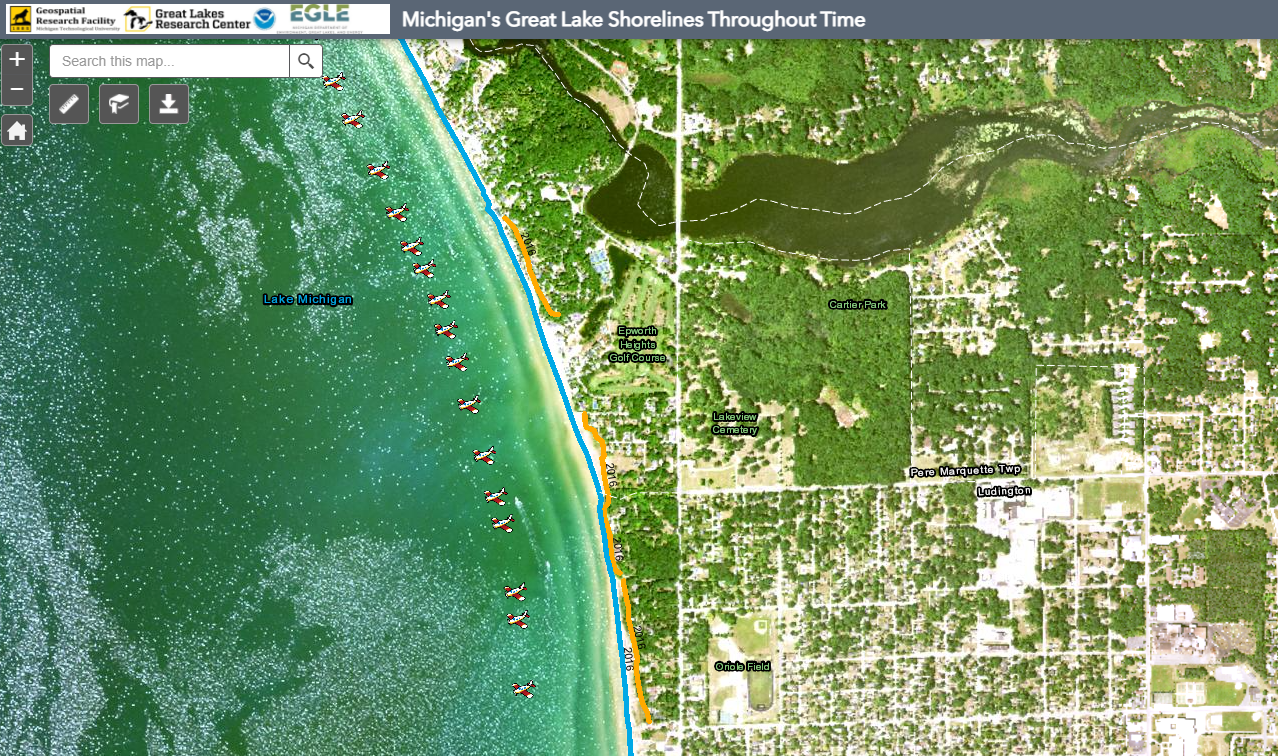
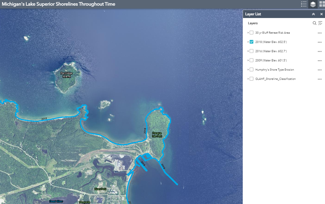
The GRF uses geospatial technology and scenario-based land-use planning methods for the purpose of protecting our coastal resources and strengthening our coastal communities' resilience in the face of coastal hazards. The GRF's team of GIS analysts began with an archive of historic aerial imagery spanning eighty years. The team meticulously georeferenced the images against contemporary shorelines, developing a photomosaic of our past shorelines at well-documented intervals and digitized the past shorelines and bluff lines. The GRF can use these digitized shorelines to visualize and analyze change over time, modeling the rate of coastal change and  applying a Coastal Vulnerability Index (CVI) for identifying areas more vulnerable to erosion. 

Understanding our coastal change over time provides critical data as EGLE responds to the growing erosion problems faced by our coastal communities.
Picture
The GRF's viewer for Lakes Huron and Michigan
Click Here for the Lake Michigan and Lake Huron Historical Shoreline Viewer
Picture
The GRF's Lake Superior Viewer
Click Here for the Lake Superior Historical Shoreline Viewer
Financial assistance for this project was provided, in part, by the Michigan Coastal Zone Management Program, Michigan Department of Environment, Great Lakes, and Energy, and is supported through a grant under the National Coastal Zone Management Act of 1972, as amended, administered by the Office for Coastal Management, National Oceanic and Atmospheric Administration.
Picture
0 Comments


Leave a Reply.

    Archives

    November 2024
    September 2024
    August 2024
    July 2024
    June 2024
    May 2024
    April 2024
    March 2024
    November 2023
    October 2023
    September 2023
    July 2023
    June 2023
    April 2023
    March 2023
    February 2023
    January 2023
    December 2022
    November 2022
    October 2022
    September 2022
    August 2022
    July 2022
    June 2022
    May 2022
    April 2022
    January 2022
    December 2021
    November 2021
    October 2021
    September 2021
    August 2021
    June 2021
    May 2021
    April 2021
    March 2021
    February 2021
    November 2020
    October 2020
    September 2020
    August 2020
    July 2020
    June 2020
    May 2020
    April 2020
    March 2020
    February 2020
    January 2020
    December 2019
    November 2019
    September 2019
    August 2019
    July 2019
    June 2019
    May 2019
    April 2019
    March 2019
    February 2019
    November 2018
    October 2018
    September 2018
    August 2018
    July 2018
    May 2018
    April 2018
    March 2018
    February 2018
    January 2018
    December 2017
    November 2017
    September 2017
    August 2017
    July 2017
    June 2017
    May 2017
    April 2017
    March 2017
    February 2017
    January 2017
    December 2016
    September 2016
    August 2016
    July 2016
    May 2016
    April 2016
    March 2016

    RSS Feed

Contact Us​

Picture
HESA Lab
Picture
  • Keweenaw Time Traveler
    • Resources >
      • About the Data >
        • About the Maps
        • About the Datasets
        • About Sharing Your Stories
      • Tutorials & Programming >
        • Tutorials & Guides
        • Programs & Lesson Plans
      • Behind the Scenes
      • Our Partners
      • Our Funders
      • Meet the Team
      • Publications
    • For Researchers
    • Project News
  • NEH Institute
    • About the Institute >
      • Host Institutions
      • Our Host Community
      • Instructor Bios
    • 2025 Fellows
    • Schedule
    • Resources >
      • Technical Resources
      • ​Virtual Workshops & Asynchronous Modules
      • In-Person Institute Program
      • Deep Mapping & Digital Humanities Resources
      • Professional Development Opportunities
  • Help