Keweenaw Time Traveler
  • Home
  • ABOUT THE PROJECT
    • About the Data >
      • About the Maps
      • About the Datasets
      • About Sharing Your Stories
    • Behind the Scenes
    • Our Partners
    • Our Funders
    • Meet the Team
    • Citizen Historian Apps
    • Time Traveling Experiences
    • Publications
  • Upcoming Events
  • Project News
  • Help

NEH Grant is Propelling the Time Traveler into the Future

9/11/2020

0 Comments

 
Picture

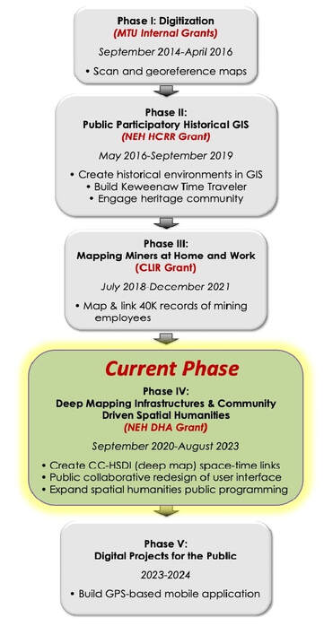
     Developing the Copper Country Historical Spatial Data Infrastructure (CC-HSDI) (aka Keweenaw Time Traveler) has been an ambitious endeavor, bringing together researchers, students, and the heritage community to build a space-time linked deep map that revolutionizes the way people use historical maps and data.  Since work started in 2015, our team has developed data-rich maps for our region between the years 1888-1950, linking different archival records such as city and business directories.  In the first three years of the project community member “citizen historians” made over 250,000 classifications and transcriptions in the three builder apps. This data is automatically added to the more than 116,000 building footprints and other records which are available in the Keweenaw Time Traveler Explore app.

     Since the beginning of the project we have been committed to community engagement, hosting 10 public design charrettes and introducing users to the Time Traveler at 21 festivals and public events between 2017-18.

     Teammates successfully published 2 dissertations, presented over 30 conference papers, and published 11 peer-reviewed papers in interdisciplinary journals which included American Quarterly, Journal of Community Heritage and Society, and Historical Methods.

     We are honored to announce that the National Endowment for the Humanities Office of  Digital Humanities has awarded us a three-year grant to move the CC-HSDI and the Keweenaw Time Traveler to the next phase! Much of the $324,985 awarded will go to support Michigan Tech students who will learn on-the-job skills in historical GIS and geospatial technology applications for public history.

Phase IV of our project has three main goals:
  1. Build more digital linkages between data. This means connecting people recorded in historical records to the houses, businesses, mines, and schools on historical maps where they lived and worked. This work is being done by Michigan Tech students under the supervision of Dr. Don Lafreniere, whose experience in “deep mapping” and historical spatial data infrastructures is underpinning our work.
  2. Redesign the Keweenaw Time Traveler Explore app interface. Even if we link millions of data points, they won’t mean anything to anyone if users can’t access or understand them. We are so excited to be partnering with Monte Consulting of Houghton to develop a beautiful interface powerful enough to deliver the data-rich “deep mapping” experience, and intuitive enough to make it all seem simple. Work is already underway on this goal, with additional assistance from the Advisory Commission of the Keweenaw National Historical Park, and an MTU grant to Co-Director Dr. Sarah Scarlett. As in Phase II, we will host charrettes to publicly try out or “beta test” the designs so far. This will model best practices in community-engaged research, critically evaluating our results and sharing them with collaborators as we go. Keep an eye out for announcements and please consider joining us at our charrettes to help make the Explore App useful for YOU!
  3. Expand public history programming. With a rich newly designed Explore App, our team will work with K-12 teachers and heritage sites in the region to make the Keweenaw Time Traveler a more useful, accessible, and vital part of public history in our community.

Picture
      Toward the end of this three-year grant period, we will also offer tools for reproducibility so that other communities might be able to build their own “deep maps.” We plan to host webinars and make freely available the process, procedures, and coding that we used. The Keweenaw Time Traveler has been developed specifically to match the history, landscape, and archival resources here in our community. Other communities will need to tailor their deep maps to their own specific needs and resources. But sharing our process should make the concepts accessible so they can be used to produce rich digital spatial humanities projects that create meaning and context in other locations. These webinars will help other scholars and communities to begin building deep maps that serve their individual needs without having to reinvent the wheel.

     This project has made, and is now able to continue making, theoretical and methodological contributions to the fields of historical GIS, spatial humanities, and public history. Phase IV will innovate our platform and methods, and empower others to use deep mapping to study and protect their own cultural heritage. We anticipate that three main groups will immediately benefit from our planned work, being the field of digital spatial humanities, researchers in social, cultural or environmental studies, and residents of Michigan’s Upper Peninsula whose work with KeTT is a contribution to their own histories.

The Keweenaw Time Traveler is made possible, in part, by our partners in MTU Social Sciences, the Advisory Council of the Keweenaw National Historical Park, and the National Endowment For the Humanities.
Picture
Picture
Picture
0 Comments


Leave a Reply.

    Archives

    February 2023
    January 2023
    December 2022
    November 2022
    October 2022
    September 2022
    August 2022
    July 2022
    June 2022
    May 2022
    April 2022
    January 2022
    December 2021
    November 2021
    October 2021
    September 2021
    August 2021
    June 2021
    May 2021
    April 2021
    March 2021
    February 2021
    November 2020
    October 2020
    September 2020
    August 2020
    July 2020
    June 2020
    May 2020
    April 2020
    March 2020
    February 2020
    January 2020
    December 2019
    November 2019
    September 2019
    August 2019
    July 2019
    June 2019
    May 2019
    April 2019
    March 2019
    February 2019
    November 2018
    October 2018
    September 2018
    August 2018
    July 2018
    May 2018
    April 2018
    March 2018
    February 2018
    January 2018
    December 2017
    November 2017
    September 2017
    August 2017
    July 2017
    June 2017
    May 2017
    April 2017
    March 2017
    February 2017
    January 2017
    December 2016
    September 2016
    August 2016
    July 2016
    May 2016
    April 2016
    March 2016

    RSS Feed

Contact Us​

Picture
Picture
HESA Lab
Picture
  • Home
  • ABOUT THE PROJECT
    • About the Data >
      • About the Maps
      • About the Datasets
      • About Sharing Your Stories
    • Behind the Scenes
    • Our Partners
    • Our Funders
    • Meet the Team
    • Citizen Historian Apps
    • Time Traveling Experiences
    • Publications
  • Upcoming Events
  • Project News
  • Help