Keweenaw Time Traveler
  • Keweenaw Time Traveler
    • Resources >
      • About the Data >
        • About the Maps
        • About the Datasets
        • About Sharing Your Stories
      • Tutorials & Programming >
        • Tutorials & Guides
        • Programs & Lesson Plans
      • Behind the Scenes
      • Our Partners
      • Our Funders
      • Meet the Team
      • Publications
    • For Researchers
    • Project News
  • NEH Institute
    • About the Institute >
      • Host Institutions
      • Our Host Community
      • Questions & Answers
      • Instructor Bios
    • 2025 Fellows
    • Schedule
    • In-Person Institute
    • Resources >
      • Technical Resources
      • ​Virtual Workshops & Asynchronous Modules
      • Deep Mapping & Digital Humanities Resources
      • Professional Development Opportunities
  • Help

Next-Level Time Travel with New Maps on KeTT’s Explorer App

5/25/2022

0 Comments

 
Author: Daniel J. Lizzadro-McPherson, Geospatial Research Scientist
You have asked for it and we have delivered! The Keweenaw Time Traveler Team is proud to announce the arrival of new maps on the latest version of the Explore App.  Take an even deeper dive into Copper Country history with over a dozen new maps digitized from a variety of archived sources!  Check out these new map sets that will be made available during and soon after the launch of our new Explore App:
  • Calumet & Hecla Property Map (1915)
  • Geologic Bedrock Quadrangle Maps (USGS: 1953-1956)
  • Geologic Map of the Keweenaw Peninsula and Western UP (USGS: 1995, 2001)
  • Keweenaw Point (1865)
  • Keweenaw Waterway Nautical Charts (USACE: 1865 - 1964)
  • Keweenaw County Map (early 1900s)
  • Keweenaw County Road Map (1950)
  • Topographic Map of Houghton-Hancock (1915)
  • Topographic Maps of Northern Houghton and Keweenaw County (1940s, 1975)
  • Town of Eagle River (1917)
  • Quincy Mine Location (1898)
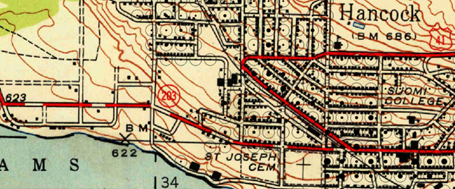
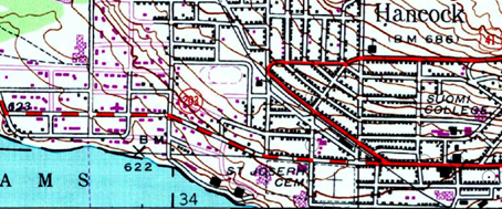
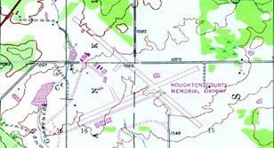
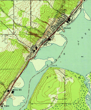
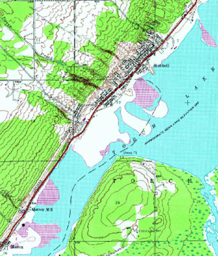
While all of the new maps enhance the Explore App in unique ways, I am particularly excited about the addition of the 1975 USGS Topographic Maps. These maps closely resemble their predecessors (the 1940 topo series), but highlight the structures, roads, and various other features that were developed or constructed after the 1950s. The new features on these maps are indicated by pink-purple symbols.
Picture
Hancock - 1940s USGS Topographic Map Series
Picture
Hancock – 1975 USGS Topographic Map Series

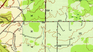
​​For me it was really impressive to see how my West Hancock neighborhood changed so dramatically between these two time slices. New roads, houses, schools, and hospitals seem to pop-up everywhere – even our tiny airport!
Picture
1940 topographic map of the Houghton County Memorial Airport area
Picture
1975 topographic map of the Houghton County Memorial Airport area

Another interesting feature on these maps is the sediment transport of stamp sands in Torch Lake. Take a look and see how the lobes of stamp sand migrate between these two time slices.
Picture
1940 topographic map of the stamp sands in Torch Lake
Picture
1975 topographic map of the stamp sands in Torch Lake

​​These are just a few examples of the hidden treasures scattered throughout the new maps on the Explore App and more maps are in development. We invite you to discover them for yourself. Happy time traveling!
0 Comments


Leave a Reply.

    Archives

    May 2025
    April 2025
    March 2025
    February 2025
    January 2025
    November 2024
    September 2024
    August 2024
    July 2024
    June 2024
    May 2024
    April 2024
    March 2024
    November 2023
    October 2023
    September 2023
    July 2023
    June 2023
    April 2023
    March 2023
    February 2023
    January 2023
    December 2022
    November 2022
    October 2022
    September 2022
    August 2022
    July 2022
    June 2022
    May 2022
    April 2022
    January 2022
    December 2021
    November 2021
    October 2021
    September 2021
    August 2021
    June 2021
    May 2021
    April 2021
    March 2021
    February 2021
    November 2020
    October 2020
    September 2020
    August 2020
    July 2020
    June 2020
    May 2020
    April 2020
    March 2020
    February 2020
    January 2020
    December 2019
    November 2019
    September 2019
    August 2019
    July 2019
    June 2019
    May 2019
    April 2019
    March 2019
    February 2019
    November 2018
    October 2018
    September 2018
    August 2018
    July 2018
    May 2018
    April 2018
    March 2018
    February 2018
    January 2018
    December 2017
    November 2017
    September 2017
    August 2017
    July 2017
    June 2017
    May 2017
    April 2017
    March 2017
    February 2017
    January 2017
    December 2016
    September 2016
    August 2016
    July 2016
    May 2016
    April 2016
    March 2016

    RSS Feed

Contact Us​

Picture
HESA Lab
Picture
  • Keweenaw Time Traveler
    • Resources >
      • About the Data >
        • About the Maps
        • About the Datasets
        • About Sharing Your Stories
      • Tutorials & Programming >
        • Tutorials & Guides
        • Programs & Lesson Plans
      • Behind the Scenes
      • Our Partners
      • Our Funders
      • Meet the Team
      • Publications
    • For Researchers
    • Project News
  • NEH Institute
    • About the Institute >
      • Host Institutions
      • Our Host Community
      • Questions & Answers
      • Instructor Bios
    • 2025 Fellows
    • Schedule
    • In-Person Institute
    • Resources >
      • Technical Resources
      • ​Virtual Workshops & Asynchronous Modules
      • Deep Mapping & Digital Humanities Resources
      • Professional Development Opportunities
  • Help