Keweenaw Time Traveler
  • Home
  • ABOUT THE PROJECT
    • About the Data >
      • About the Maps
      • About the Datasets
      • About Sharing Your Stories
    • Behind the Scenes
    • Our Partners
    • Our Funders
    • Meet the Team
    • Citizen Historian Apps
    • Time Traveling Experiences
    • Publications
  • Upcoming Events
  • Project News
  • Help

Tech Surge Presentation

10/5/2020

0 Comments

 
Picture
            Geospatial Research Scientists Ryan Williams and Daniel Lizzadro-McPherson, in collaboration with Dr. Don Lafreniere and Dr. Guy Meadows, presented their work to map historic rates of change along Lake Michigan’s shoreline, at the Lakebed 2030 Tech Surge conference. The event took place in October of 2019 in Traverse City. At the conference, Ryan and Daniel shared the latest technological advancements with Great Lakes communities and businesses, which are reliant on shoreline data to make important decisions that impact everyone living or working along the shore.

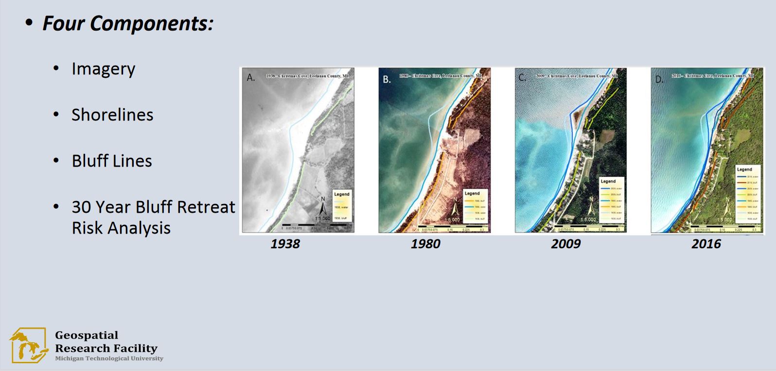
            “A main component of these land use planning methods is an understanding of the history of shoreline and coastal bluff change over time. This project uses Geographic Information Systems (GIS) to map historic aerial images from 2016, 2009, 1980 and 1938 and used those images to create historic shoreline and bluff line features that could be used to visualize historic coastlines and characterize areas vulnerable to future shoreline change.” (1)

            Community Planning groups such as Networks Northwest and Land Information Access Association were in attendance and were aided by the creation of the Community Coastal Resiliency Strategy, and a GIS map and app containing imagery and maps of Great Lakes shorelines, bluff lines, and a 30-year bluff-retreat risk analysis. These groups and more have gained a new tool and insight which can be used to move business, and residential development, forward along Great Lakes shores.

            ***Financial assistance for this project was provided, in part, by the Michigan Coastal Zone Management Program, Michigan Department of Environment, Great Lakes, and Energy
0 Comments


Leave a Reply.

    Archives

    February 2023
    January 2023
    December 2022
    November 2022
    October 2022
    September 2022
    August 2022
    July 2022
    June 2022
    May 2022
    April 2022
    January 2022
    December 2021
    November 2021
    October 2021
    September 2021
    August 2021
    June 2021
    May 2021
    April 2021
    March 2021
    February 2021
    November 2020
    October 2020
    September 2020
    August 2020
    July 2020
    June 2020
    May 2020
    April 2020
    March 2020
    February 2020
    January 2020
    December 2019
    November 2019
    September 2019
    August 2019
    July 2019
    June 2019
    May 2019
    April 2019
    March 2019
    February 2019
    November 2018
    October 2018
    September 2018
    August 2018
    July 2018
    May 2018
    April 2018
    March 2018
    February 2018
    January 2018
    December 2017
    November 2017
    September 2017
    August 2017
    July 2017
    June 2017
    May 2017
    April 2017
    March 2017
    February 2017
    January 2017
    December 2016
    September 2016
    August 2016
    July 2016
    May 2016
    April 2016
    March 2016

    RSS Feed

Contact Us​

Picture
Picture
HESA Lab
Picture
  • Home
  • ABOUT THE PROJECT
    • About the Data >
      • About the Maps
      • About the Datasets
      • About Sharing Your Stories
    • Behind the Scenes
    • Our Partners
    • Our Funders
    • Meet the Team
    • Citizen Historian Apps
    • Time Traveling Experiences
    • Publications
  • Upcoming Events
  • Project News
  • Help